French School Manuscript Map of Prague during the War of Austrian
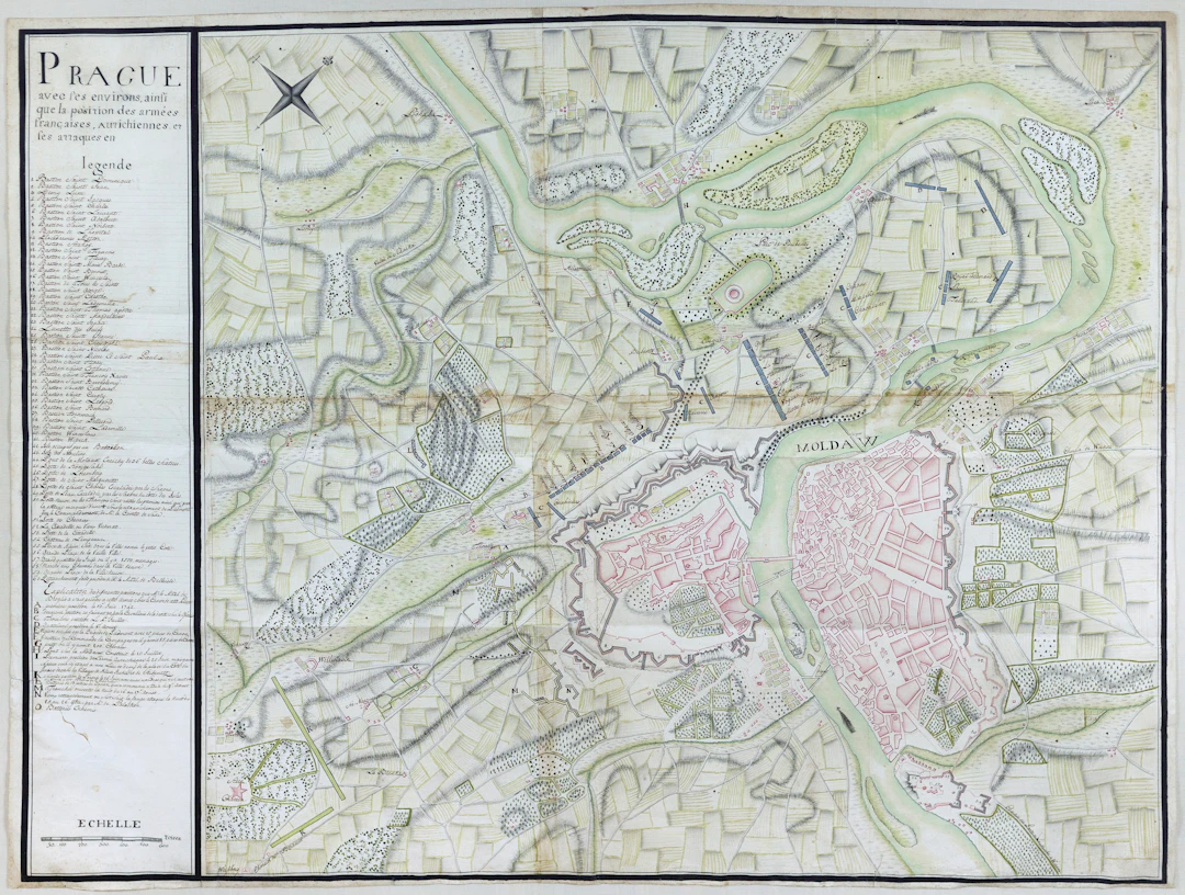
FRENCH SCHOOL (Mid-18th Century). Prague avec les environs, ainsi que la position des armees francais autrichiennes et ses attaques... Manuscript map in pen and ink with original hand color. France, c. 1742. 34 1/8" x 44 3/8" sheet; 41 1/2" x 51 1/2" framed. An unparalleled glimpse into a significant moment in 18th-century European History. Manuscript map depicting the positions of French troops under the command of Marshal Broglie during the War of Austrian Succession. With a legend numbering 1-60 and A-O. This exquisitely drawn map is a unique and fascinating historical document relating directly to the siege of Prague, which took place during the War of Austrian Succession (1740-1748). In the summer of 1741, Charles Albert of Bavaria, hoping to gain control of the Holy Roman Empire and the Hapsburg lands, sent an army to invade Bohemia. His strongest allies were the French, who dispatched an army into southern Germany, led by Marshal Francois M. de Brodlie, to support the Bavarians in their hopes for predominance. In October the Franco-Bavarians marched on Prague, which fell on November 26, 1741. The French and Bavarians quickly consolidated control of western and central Bohemia, and Charles Albert was crowned King of Bohemia on December 19. The speedy victory notwithstanding, the allied invaders were far from assured of long-term success. Even as they captured Bohemia, Maria Theresa of Austria, daughter of the later emperor Charles VI, was planning to regain Silesia from Frederick of Prussia, as well as defeat the Bavarians and the French. On January 24, 1742, the very day that Charles Albert was elected emperor - assuming the name Charles VII - his capital in Bavaria was being captured by the Austrians. Planned cooperation among the Prussians, Bavarians and French collapsed when the Bavarians rushed back to protect what was left of their country from the Bavarians. The French under Marshal Broglie were too weak to leave the vicinity of Prague. Charles of Lorraine, who was now in command of Bohemia, returned from a campaign against Frederick in Silesia and began to lay siege to the city, and the beleaguered French in June. This large-scale, strikingly detailed and vividly colored map shows Broglie's positions before and after the siege, which ended on September 14 when Charles marched to confront a French invasion in Franconia. The extensive legend indicates the locations of numerous bastions, forts, bridges, city gates, and citadels, as well as the position of Broglie's troops on a number of different dates. The plan itself is expertly delineated, conveying a vast amount of complex information in a remarkably clear and highly visually engaging image.
Stima:€10,540.81
Vai all’astaVedi tutti gli oggetti diArader GalleriesoArte, Pittura e Arti Grafiche